Greece responded immediately to what it termed as the latest major Turkish provocation in the eastern Mediterranean, with Athens this time pointing to an even more egregious action by the increasingly belligerent Erdogan administration – hydrocarbon exploration as close as 6.5 nautical miles from a Greek isle – and with a most confrontational timing, i.e. ahead of new exploratory bilateral talks.
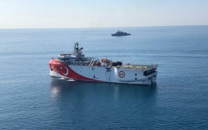
Specifically, the Turkish maritime station in the southern Anatolia city of Antalya on Sunday abruptly issued a NAVTEX (navigational notice), announcing that a Turkish survey vessel, the Oruc Reis, will conduct hydrocarbon exploration as close as 6.5 nm south of Kastellorizo and 22 nm southeast of the large island of Rhodes.
Athens immediately responded with a “counter” NAVTEX, issued by the Hellenic Navy’s hydrographic service, calling the Turkish notice “illegal”, and warning that proposed activities by the Turkish side are within Greece’s continental shelf.
The foreign ministry in Athens also warned that the act is a major escalation in tension and constitutes a threat to peace and security in the eastern Mediterranean.
Perennial EU-candidate Turkey is not a signatory nor does it apply customary law emanating from the landmark 1982 United Nations Convention on the Law of the Sea (UNCLOS) in areas that it disputes, instead it applies UNCLOS provisions in the Black Sea, such as EEZ and territorial waters.
Moreover, successive Turkish governments since 1996 operate under a resolution by the Turkish grand assembly at the time, considering any extension of Greece’s territorial waters from six to 12 nautical miles as a “cause of war” (casus belli). Extension of territorial waters is prescribed in UNCLOS and not the subject of bilateral or multilateral talks or negotiations, in contrast to the delimitation of exclusive economic zones.
The latest Turkish provocation in the east Mediterranean comes nearly a year since a controversial deal was signed between Ankara and the embattled term-limited UN recognized government in Tripoli, an agreement that “drew” maritime borders between non-abutting Turkey and Libya that erased every island in between them – also counter to UNCLOS.
The NAVTEX issued by the Greek station in the Crete city of Irakleio reads:
IRAKLEIO STATION NAVWARN 596/20
KASTELORIZO SEA
1. UNAUTHORIZED STATION HAS BROADCAST NAVTEX MESSAGE NUMBER FA06-1262/20 IN HELLENIC NAVTEX SERVICE AREA, REFERRING TO UNAUTHORIZED AND ILLEGAL ACTIVITY IN AN AREA THAT OVERLAPS THE GREEK CONTINENTAL SHELF. IRAKLEIO NAVTEX STATION HAS THE AUTHORITY TO BROADCAST NAVTEX MESSAGES IN THE AREA.
2. ALL MARINERS ARE REQUESTED TO DISREGARD NAVTEX MESSAGE NUMBER FA06-1262/20.
3. CANCEL THIS MESSAGE 222059 UTC OCT 20.
Ι.Ι.
Turkey’s NAVTEX for Oruc Reis reads:
TURNHOS N/W : 1262/20 (Antalya NAVTEX Station) (Published Date: 11-10-2020 23:33)
TURNHOS N/W : 1262/20
MEDITERRANEAN SEA
1. SEISMIC SURVEY, BY R/V ORUÇREİS, ATAMAN AND CENGİZHAN FROM 120600Z OCT 20 TO 222059Z OCT 20 IN AREA BOUNDED BY;
35 34.82 N – 028 00.13 E
35 34.83 N – 028 28.78 E
35 36.77 N – 028 28.77 E
35 59.87 N – 029 22.85 E
35 59.87 N – 029 34.20 E
35 59.92 N – 029 59.75 E
35 42.52 N – 030 04.35 E
34 49.53 N – 028 00.07 E
35 09.32 N – 028 00.05 E
6 NM BERTH REQUESTED.
2. CANCEL THIS MESSAGE 222059Z OCT 20.


